Cookie Consent by Free Privacy Policy Generator Update cookies preferences
Showing posts with label Hiking. Show all posts

Tuesday, February 7, 2023

The Banff National Park

Banff National Park

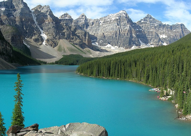
The turquoise Moraine Lake seen from a viewpoint at its north bank.

Banff National Park is located in the Canadian Rockies and is one of Canada's oldest and most popular national parks. Established in 1885, Banff spans over 6,641 square kilometers and is home to an array of breathtaking landscapes, including mountains, glaciers, lakes, and forests.

One of the most famous attractions in Banff National Park is Lake Louise, a turquoise blue lake surrounded by the Victoria Glacier and majestic peaks. Another must-see location is Moraine Lake, which offers stunning views of the surrounding mountains and is a popular spot for hiking, kayaking, and canoeing.

In addition to its natural beauty, Banff National Park also offers a range of activities for visitors to enjoy. From skiing and snowboarding at Mt. Norquay, to hot springs soaking at the Banff Upper Hot Springs, there's something for everyone. The park also has an extensive network of hiking trails, ranging from easy walks to challenging mountain climbs.

Banff is also a hub for wildlife, including grizzly bears, wolves, mountain lions, and elk. Visitors are encouraged to take precautions while hiking, such as making noise to alert wildlife of their presence, and carrying bear spray.

Tuesday, December 27, 2016

Sunrise in the Downtown of Santa Ana city

Sunrise in Santa Ana city.

Where is Santa Ana?

Santa Ana is the second largest city in El Salvador, located 64 kilometers northwest of San Salvador, the capital city.
Santa Ana downtown-El Salvador
Cathedral at the morning.

A major processing center of El Salvador´s sizable coffee bean industry is located near Santa Ana. Santa Ana, which is the second city in importance in El salvador, has become a very popular tourist destination, especially for tourist eager to learn about Salvadorean culture and traditions.

Friday, July 3, 2015

Bora Bora

Bora Bora 

Is an island in the Leeward group of the Society Islands of French Polynesia, an overseas collectivity of France in the Pacific Ocean. is Tahiti´s crown jewel a true Polynesian island paradise that tourist the world over consider the ultimate tropical vacation destination. The island, located about 143 miles(230 km) northwest of Papeete, is surrounded by a lagoon and a barrier reef.
Bora-Bora
Bora Bora general view
In the centre of the island are the remnants of an extinct volcano rising to two peaks, Mount Pahia and Mount Otemanu, the highest point at 2385 ft. Hollywood and film industries from most other parts of the globe, have never tired of capturing its spectacular topography.

Monday, June 29, 2015

Rocky Mountains

Rocky Mountains

The majestic Rocky Mountains are a major tourist location in the western United States. The Rocky Mountain are a major mountain range in western North America. The mountains stretch more than 3,000 miles from the northernmost part of British Columbia, in western canada, to New Mexico, in the southwestern United States. within the North American Cordillera, the Rockies are somewhat distinct from the Pacific Coast Ranges and The Cascada Range and Sierra Nevada which all lie further to the west.
Hiking vacation in Rocky Mountain National Park
Hiking vacation in Rocky Mountain National Park By Dennis Flood

Monday, May 4, 2015

Berchtesgaden National Park

Berchtesgaden National Park 

Is in the south of Germany, on its border with Austria, the national park was established in 1978 to protect the landscapes of the Berchtesgaden Alps. Headquartered in the town of Berchtesgaden, the park was designated a UNESCO Biosphere Reserve in 1990.

Berchtesgaden national park
It is the only alpine biosphere reserve in Germany with an elevation of up to 2,700 meters above sea level. However, the transition zone is situated in low elevated areas in the north of the mountain ranges.

Friday, January 23, 2015

Tikal National Park, Guatemala.

Tikal National Park

The Tikal National Park, in the Peten region in Northern Guatemala, comprises an area of 222 mi² or 576 km². The park contains some of the most fascinating archaeological remains of the ancient Maya Civilization. Tikal is the ruins of an ancient city found in a rainforest. Ambrosio Tut, a gum-sapper, first saw Tikal in the mid nineteenth century, from the top of a sapodilla tree, obrserving various temple's roof combs in the distance and reported the ruins to a La Gaceta, a Guatemalan newspaper, which named the site Tikal. The Berlin Academy of Science's Magazine then republished the report in 1853. Archaeologist and treasure hunters then began visiting the forest. Today tourism to the site may help protect the rainforest.
Tikal National Park
Temple I or Great Jaguar around 1900's

Monday, January 12, 2015

Caño Cristales, A five color river in Colombia

Caño Cristales

Is a river of Colombia is located in the Sierra de la Macarena, in the municipality of the same name, in the department of Meta.
"Los ochos" in Caño Cristales
It has been called "the river of five colors", "the rainbow melted" or even "the most beautiful river in the world", since in his background freshwater algae of different colors, producing the sensation reproduce being in front of a river of five colors: red, yellow, green, blue and black, mainly.

Friday, July 11, 2014

Yellowstone, the first national park in the world!

Yellowstone National Park

Is a national park located primarily in the U.S. state of Wyoming, although it also extends into Montana and Idaho. It was established by the U.S. Congress and signed into law by President Ulysses Grant on March 1, 1872. Yellowstone, widely held to be the first national park in the world, is known for its wildlife and its many geothermal features, especially "Old Faithfull Geyser", one of the most popular features in the park. 
Yellowstone_National_park_hot_Spring
Mammoth hot spring in Yellowstone
Yellowstone has many types of ecosystems, but the subalpine forest is most abundant. It is part of the south Central Rockies forest ecoregion.
Native Americans have lived in the Yellowstone region for at least 11,000 years.
Yellowstone_River
Lower Falls of the Yellowstone River

Tuesday, July 8, 2014

The Kakadu National Park, an archaeological and ethnological site.

The Kakadu National Park

Is a protected area, located within the Alligator Rivers Region of  the Northern Territory of Australia, 171 km southeast of Darwin.  It covers an area of 19,804 km² (7,646 mi²), extending nearly 200 km from north to south and over 100 km from east to west. It is a unique example of a complex of ecosystems, including tidal flats, floodplains, lowlands and plateaux, and provides a habitat for a wide range of rare or endemic species of plants and animals.

Australia-Kakadu-Aboriginal
This unique archaeological and ethnological reserve, has been inhabited continuously for more than 40,000 years. The cave, paintings, rock carvings and archaeological sites record the skills and way of life of the region´s inhabitants, from hunter-gatherers of prehistoric times to the Aboriginal people still living there.

Saturday, July 5, 2014

Christ the Redeemer in National Park da Tijuca

Christ the Redeemer

Keeping a watchful eye over the people of Rio de Janeiro, the Statue of Christ the Redeemer or Cristo Redentor (in Portuguese) sits atop Corcovado 2,300 feet (700 meters) above the city. Is a larger than life statue of Jesus Christ with his arms outstretched, a symbol of peace that stands almost 131.23 ft (40 meters) high.
Rio de Janeiro, Brazil
Rio de Janeiro in the night.

Monday, March 3, 2014

The Paradise of the caves of Lanquín

The Lanquin Caves National Park

You can see also: Semuc Champey

The Lanquin Caves National Park is a protected area consisting of a large limestones cave system located 1 km (0.62 mi) west of Lanquín in the department of  Alta Verapaz, Guatemala. The cave system Lanquin was declared a national park in 1955 covering an area of about 11 hectares (0.1 km²). Near the entrance passes a river also called Lanquín walking about 12 miles to the river Cahabon.

Grutas de Lanquín National Park
 Located 1 km from the municipal seat of Lanquín, on the road that leads to Coban, passes over the input Lanquin Caves, one of the first declared protected areas in Guatemala.

Wednesday, February 26, 2014

Saturday, February 22, 2014

Hawaii Volcanoes National Park

Hawaii Volcanoes National Park

Established in 1916, is a United States National Park located in the U.S. States of Hawaii on the island of Hawaii. The park encompasses 333,000 acres from the summit of Maunaloa(Is one of five volcanoes that form the island of Hawaii in the U.S. State of Hawaii in the pacific Ocean) to the sea. It encompasses two active volcanoes: Kilauea(One of the world´s most active volcanoes) and Mauna Loa(The world´s most massive subaerial volcano).
Volcanoes-National-Park
Here you´ll find 150 miles of hiking trails through volcanic craters, scalded deserts and rainforests as well as a museum, petroglyphs, a walk-in lava tube and two active vocanoes. 
The park gives scientists insight into the birth of the Hawaiian Islands and ongoing studies into the processes of vulcanism. For visitors, the park offers dramatic volcanic landscapes as well as glimpses of rare flora and fauna.

Saturday, February 15, 2014

A monkey´s paradise in Japan´s Jigokudani Monkey Park

Japan´s Jigokudani Monkey Park

Is in Yamanouchi, Shimotakai District, Nagano Prefecture. It is part of the Joshin-etsu Kogen National Park, and is located in the valley of the Yokoyu-River, in the Northern part of the prefecture. The name Jigokudani, meaning "Hell´s valley" is due to the steam and boiling water that bubbles out of small crevices in the frozen ground, surrounded by steep cliffs and formidably cold and hostile forests.
Joshinetsu-Kogen-National-Park
Jigokudani(hell valley) hot spring
In this place snow covers the ground for 4 months a year, the heavy snowfalls, an elevation of 850 metres and being only accesible via a narrow 2 km(1.24 mi) footpath through the forest, keep it uncrowded despite being relatively well-known.

Wednesday, February 5, 2014

"The Impossible National Park"

The Impossible National Park

The Impossible National Park is a national park in El Salvador. It was created on January 1, 1989 and covers an area of 5,000 hectares. It has an altitude of between 250 and 1,425 metres.
One of the entrances to the Park.

The Impossible is the largest national park of El Salvador, is located in the Pacific coastal elevations of Ahuachapán, between the municipalities of San Francisco Menéndez and Tacuba, south-west of the "Ruta de las Flores"(the flowers route).This protected area is considered the most important natural relic of the country, as a globally threatened (tropical dry forest and dry tropical montane) ecosystem, but also for being one of the last refuges for an incredibly diverse wildlife community, source of water for the area and owner of scenic beauty for sustainable tourism development.

Wednesday, January 29, 2014

Knowing the Mayan Culture in Panajachel, Sololá.

Panajachel, Sololá, Guatemala.

Its complete name is San Francisco Panajachel, is a PreColumbian village of origin Cakchiquel, located on one side of river of the same name and on the shores of Lake Atitlan, was the scene of the final battle between Spaniards and their allies the Cakchiquel against Tzujiles and seat Franciscan missionaries who founded a convent.
Solola-Atitlan-Panajachel
Dawning on Panajachel
Currently, the town is situated amidst coffee plantations, gardens and vegetable plots. It is the most important center of the area, which is why most concentrated hotels, restaurants, nightclubs, entertainment and shopping center. It is ideal for craft shopping.
Panajachel-Solola-Atitlan
Typical sales, Santander street
West of Panajachel, in the Valley of San Buenaventura, historical place of the lake, is a nature reserve of 120 hectares and a butterfly. The forest has several walking trails and an organic coffee plantation.

Monday, January 27, 2014

The great waves for surfers in Zicatela beach, Puerto Escondido.

Zicatela beach

Location

The zicatela beach is located to the east of Puerto Escondido, in the Mexican state of Oaxaca,  his fame is due to the practice of surfing, as every year are held a national and international surfing tournaments.
It means instead of large spines and has a length of 3km, with its beauty captives visitors, especially those who practice surfing, since the third beach is regarded worldwide for practicing this sport, according to the wave heigth. At the national level ranked first.
Surf-zicatela-wave
Zicatela wave
The most important tournament takes place in November. Due to the large growth of Puerto Escondido and the construction of hotels near the beach, The waves have lost a lot of have an average heigth of 15 meters (49.21 feets) have become orders of 10 mt.(32.81 ft) to 12 mt.(39.37 ft).

Sunday, January 26, 2014

The Historical city of León, Nicaragua.

León, Nicaragua

"Santiago de los Caballeros de Leon" is a city and municipality in Nicaragua, provincial capital of the homonymous departament, located in the northwest of the Central American country.
Although less populous than Managua(the capital), Leon has been the intellectual home of the nation, with a university founded in 1813. León is also an important industrial center and trading Nicaragua. Until the appointment of Managua the capital of Nicaragua, León rivaled Granada for such representation.
Nicaragua-Leon
Church of "La Recolección", León.

It is also the second largest city in Nicaragua, after Managua. It was founded by the spaniards as "Santiago de los Caballeros de Leon" and rivals Granada, Nicaragua, in the number of historic Spanish colonial churches, secular buildings, and private residences. 

Friday, January 24, 2014

The Amazing Corcovado National Park

Corcovado National Park

Is a national park on the Osa Peninsula in southwestern  Costa Rica,  which is part of the Osa Conservation Area. It was established on 24 October 1975, and encompasses an area of 424 Km²(164 mi²). It is the largest park in Costa Rica and protects about a third of the Osa Peninsula.
Beach-Corcovado-National Park
Corcovado National Park Beach
It is widely considered the crown jewel in the extensive system of national parks and biological reserves spread across the country. The ecological variety is quite stunning. Not only is the park very popular with tropical ecologists, a visitor can expect to see an abundance of wildlife. 


Wednesday, January 22, 2014

Utila a Beautiful tropical island for tourism

Utila Island

Utila is one of the three main islands of the insular department of Bay Islands of the republic of Honduras.
Map of the Utila Island
Map of Utila
Utila is the smallest of the islands that make up the department of the Bay Islands in Honduras Caribbean. Despite it´s small size (it measures just seven miles long by three wide), most of the island is uninhabited. It is in the Southeast corner, where your main town, Harbor Easter(or simply Utila), and most of the tourist facilities.